Originally posted by BERNIE MOSFET
View Post
Announcement
Collapse
No announcement yet.
Missing 777
Collapse
X
-
Missing Malaysian plane: Could it have landed?
(CNN) -- Yet another theory is taking shape about what might have happened to missing Malaysia Airlines Flight 370: Maybe it landed in a remote Indian Ocean island chain.
The suggestion -- and it's only that at this point -- is based on analysis of radar data revealed Friday by Reuters suggesting that the plane wasn't just blindly flying northwest from Malaysia.
Reuters, citing unidentified sources familiar with the investigation, reported that whoever was piloting the vanished jet was following navigational waypoints that would have taken the plane over the Andaman Islands.
The radar data doesn't show the plane over the Andaman Islands, but only on a known route that would take it there, Reuters cited its sources as saying.
Andaman Island editor: 'No plane here'
The theory builds on earlier revelations by U.S. officials that an automated reporting system on the airliner was pinging satellites for hours after its last reported contact with air traffic controllers. That makes some investigators think the plane flew on for hours before truly disappearing.
Aviation experts say it's possible, if highly unlikely, that someone could have hijacked and landed the giant Boeing 777 undetected.
But Denis Giles, editor of the Andaman Chronicle newspaper, says there's just nowhere to land such a big plane in his archipelago without attracting notice.
Indian authorities own the only four airstrips in the region, he said.
"There is no chance, no such chance, that any aircraft of this size can come towards Andaman and Nicobar islands and land," he said.
The Malaysian government said Friday it can't confirm the report.
And a senior U.S. official on Thursday offered a conflicting account, telling CNN that "there is probably a significant likelihood" the plane is on the bottom of the Indian Ocean.
Regardless, India has deployed assets from its navy, coast guard and air force to the south Andaman Sea to take part in a search for Flight 370, the country's Ministry of Defense said Friday. The Indian navy is leading the operation, and its Maritime Operations Center in New Delhi is coordinating the effort, the ministry said.
Indian search teams are combing large areas of the archipelago. Two aircraft are searching land and coastal areas of the island chain from north to south, an Indian military spokesman said Friday, and two coast guard ships have been diverted to search along the islands' east coast.
More on the landing theory
James Kallstrom, a former FBI assistant director, said it's possible the plane could have landed, though he added that more information is needed to reach a definitive conclusion. He referred to the vast search area.
"You draw that arc and you look at countries like Pakistan, you know, and you get into your Superman novels and you see the plane landing somewhere and (people) repurposing it for some dastardly deed down the road," he told CNN's Jake Tapper on Thursday.
"I mean, that's not beyond the realm of realism. I mean, that could happen."
Even so, he acknowledged the difficulty of reaching firm conclusions with scraps of information that sometimes conflict.
"We're getting so much conflicting data," he said. "You veer one way, then you veer the other way. The investigators need some definitive, correct data." Yet another theory is taking shape about what might have happened to missing Malaysia Airlines Flight 370: Maybe it landed in a remote Indian Ocean island chain

 Malaysia’s leader said Saturday the disappearance of Malaysia Airlines Flight 370 was the result of “deliberate action.” Earlier, a Malaysian official said it was “conclusiv…
Military radar data suggests a Malaysia Airlines jetliner missing for nearly a week was deliberately flown hundreds of miles off course, heightening suspicions of foul play among investigators, sources told Reuters on Friday.
Analysis of the Malaysia data suggests the plane, with 239 people on board, diverted from its intended northeast route from Kuala Lumpur to Beijing and flew west instead, using airline flight corridors normally employed for routes to the Middle East and Europe, said sources familiar with investigations into the Boeing 777’s disappearance.
Two sources said an unidentified aircraft that investigators believe was Flight MH370 was following a route between navigational waypoints when it was last plotted on military radar off the country’s northwest coast.
This indicates that it was either being flown by the pilots or someone with knowledge of those waypoints, the sources said.
The last plot on the military radar’s tracking suggested the plane was flying toward India’s Andaman Islands, a chain of isles between the Andaman Sea and the Bay of Bengal, they said.
A third source familiar with the investigation said inquiries were focusing increasingly on the theory that someone who knew how to fly a plane deliberately diverted the flight
Comment
-
Massive clusterfuck.
Here's some pretty detailed info that shows that people are probably keeping secrets
In a far more detailed description of the military radar plotting than has been publicly revealed, the first two sources said the last confirmed position of MH370 was at 35,000 feet about 90 miles (144 km) off the east coast of Malaysia, heading towards Vietnam, near a navigational waypoint called “Igari”. The time was 1:21 a.m..
The military track suggests it then turned sharply westwards, heading towards a waypoint called “Vampi”, northeast of Indonesia’s Aceh province and a navigational point used for planes following route N571 to the Middle East.
From there, the plot indicates the plane flew towards a waypoint called “Gival”, south of the Thai island of Phuket, and was last plotted heading northwest towards another waypoint called “Igrex”, on route P628 that would take it over the Andaman Islands and which carriers use to fly towards Europe.
The time was then 2:15 a.m. That is the same time given by the air force chief on Wednesday, who gave no information on that plane’s possible direction.
Comment
-
what is a stronger synonym of clusterfuck? We might need to invent one
 A signal detected by two stations indicated a small tremor occurred on the floor of the sea near where the Boeing 777 was last detected.
'Seismic Event' Close to Missing Jet Path: China Scientists
BEIJING - A “seismic event” consistent with an airplane crash has been detected on the sea floor close to where the missing Malaysia Airlines jet lost contact with air traffic control on Saturday, Chinese scientists said Friday.
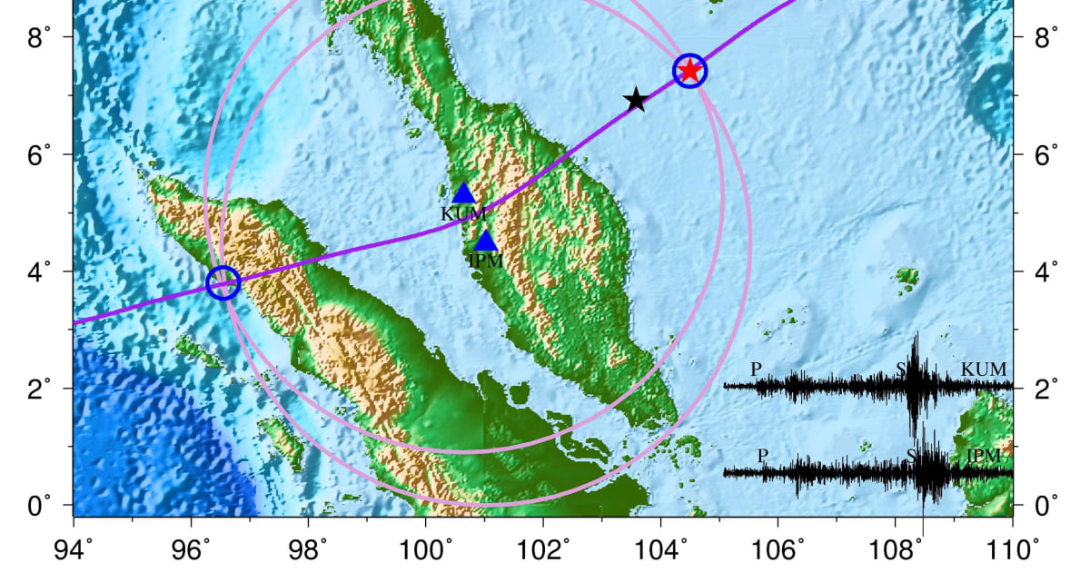
The signal detected by two stations in Malaysia appeared to indicate that a small tremor occurred on the floor of the sea at 2:55 a.m. about 95 miles south of Vietnam, the scientists said in a statement posted on the website of the University of Science and Technology of China.
"It was a non-seismic zone, therefore judging from the time and location of the event, it might be related to the missing MH370 flight," said the statement. “If it was indeed an airplane crashing into the sea, the seismic wave strength indicated that the crash process was catastrophic.”
The area where the tremor was detected about 70 miles from where the Boeing 777 was last heard from, and 85 minutes after the jet carrying 239 people lost contact, according to South China Morning Post newspaper.

Comment
-
I don't see how a plane, even flying at full speed straight into solid ground, would have enough energy to cause a tremor, unless of course there is a massive amount of explosives in that plane.
Add the fact that they likely hit the water first, and the ocean absorbed every bit of that crash. Look at how quickly a bullet stops when fired under water.
Comment
-
Pardon the translation... the source page looks like this:Originally posted by Big A View PostI don't see how a plane, even flying at full speed straight into solid ground, would have enough energy to cause a tremor, unless of course there is a massive amount of explosives in that plane.
Add the fact that they likely hit the water first, and the ocean absorbed every bit of that crash. Look at how quickly a bullet stops when fired under water.
中科大检测到可能与马航飞机坠海相关的海底事件
( 2014-03-14 )
中国科学技术大学地震与地球内部物理实验室温联星研究组在马来西亚与越南交界海域检测到一次海底事件。 事件发生于当地时间2014年3月8日2点55分6秒,其中可能的两个地点之一位于北纬7度25分、东经1 04度30分,距离当日马来西亚飞往北京的MH370航班最后失联时间(1点30分)后约一个半小时,最后 失联地点的东北方向约116公里(72英里)。该海域是无地震区,因此根据两件事件的发生时间和地点判断, 所检测到的海底事件有可能是马航MH370航班坠海失事所造成。
温联星研究组在马来西亚境内的两个地震仪记录中检测到海底事件,并利用地震信号进行定位。研究组利用两 台站的直达压缩波走时差和各台站的剪切波与压缩波走时差来定位事件位置。2014年3月8日马来西亚飞往北 京的MH370航班失联至今,尽管各国家利用军舰、飞机、卫星等各种手段一直在搜索,至今仍然毫无音信。如 果中科大研究组检测到的海底事件确是飞机坠海事件,其激发的地震波强度表明飞机最后坠海过程是 灾难性的。
But here's a snip...
Star Alliance temperature detected in the two study groups within Malaysia seismograph records the event in the seabed , and the use of the seismic signal for positioning. Two research groups use direct compression wave station go jet lag and shear waves and compression stations each wave travel time difference to locate the event location
red five-pointed star is detected seabed event location; blue triangle seismic stations (due to weak signal, only two distance events the nearest station clearly identifiable seismic phases). Black waveform is observed seismograms, shear waves and compression waves marked with S and P, respectively. Pink circles under the shear waves and compression waves stations may take the position determined by the difference of the event, and the purple curve under compression waves may go directly to the position of the two stations to determine the difference events; purple and pink circles location at the junction of the curve to determine the submarine incident (blue circle is the place of the error range).
Comment
-
And I just found this (not from the chinese site, but just underwater seismometer info in general)Originally posted by Big A View PostI don't see how a plane, even flying at full speed straight into solid ground, would have enough energy to cause a tremor, unless of course there is a massive amount of explosives in that plane.
Add the fact that they likely hit the water first, and the ocean absorbed every bit of that crash. Look at how quickly a bullet stops when fired under water.
This image taken by ROV Ventana shows the MOBB seismometer being lowered into a plastic sleeve in the seafloor, about 1,000 meters below the surface of Monterey Bay. The seismometer was buried in the seafloor to shield it from the tiny vibrations caused by ocean-bottom currents and waves at the ocean surface

They are talking about being able to detect surface waves from over 3000 ft depths.
Comment
-
So it only went 70 miles away in almost an hour and a half? Did it fly in circles?Originally posted by Strychnine View PostThe area where the tremor was detected about 70 miles from where the Boeing 777 was last heard from,*and 85 minutes after the jet carrying 239 people lost contact, according to South China Morning Post newspaper.
Comment
-
Total loss of hydraulics? Still leaves too much else unexplained.Originally posted by jluv View PostSo it only went 70 miles away in almost an hour and a half? Did it fly in circles?
Comment
-
The black box emits a 60hz transmission to help locate it, but it only has enough battery power for a month or two at most. I remember them searching for the air france flight this way in that documentary series "Air Disasters." This one is playing out very similarly. I believe it took them 1-2 years to find the plane."When the people find that they can vote themselves money, that will herald the end of the republic." -Benjamin Franklin
"A democracy will continue to exist up until the time that voters discover that they can vote themselves generous gifts from the public treasury." -Alexander Fraser Tytler
Comment


Comment